Article

Applying Circulating and Ecological Sphere (CES) Concept for Post-Pandemic Development: A Case of Hingna Tahsil, Nagpur (India)

1
Department of Architecture and Planning, Visvesvaraya National Institute of Technology, South Ambazari Road, Nagpur 440-010, India
2
Integrated Sustainability Center, Institute for Global Environmental Strategies (IGES), 2108-11 Kamiyamaguchi, Hayama 240-0115, Japan
*
Authors to whom correspondence should be addressed.
Sustainability 2022, 14(15), 9386; https://doi.org/10.3390/su14159386
Submission received: 23 May 2022 / Revised: 24 June 2022 / Accepted: 26 July 2022 / Published: 31 July 2022

Abstract

:
COVID-19 has become one of the most significant events in the history of globalization. The prolonged ‘lockdown’ adopted across various countries in the world as a countermeasure for containing the spread of the virus profoundly brought forth socio-economic and infrastructural vulnerabilities in urban as well as rural parts of India. While urban and rural areas have been greatly studied with respect to the environment, human health, safety, livelihoods, associated risks, etc., in the context of pandemics, many of these studies seldom accommodate their interdependency as a pragmatic approach to planning. This is observed to be primarily due to the dynamic and diverse nature of interactions coupled with the development disparities between rural and urban areas, thereby adding complexity to development decision making. The present study, therefore, applies the lens of the circulating and ecological sphere (CES), introduced by the Japanese government for the localization of resource flows between urban–rural regions, to consider possible alternative development approaches to achieve smooth transitions during pandemics through the case study area located in Hingna tahsil in the Nagpur Metropolitan Area, India. The methodology uses the critical examination of rural–urban linkages amidst the crisis through key-informant surveys involving representatives from local governments. Using this feedback and spatial analysis tools, the research identifies probable entry points in post-pandemic regional planning. The research contributes to understanding the impact of spatial development during pandemics through ground-based evidence. The findings from this research highlight the need to manage rural dependencies on urban areas and underline the potential of the rural–urban linkage as an approach, acknowledged and emphasized through CES, for managing such regional-scale hazards. The investigation concludes with the discussion and future research scope for achieving the pronounced needs reflected through the study.

1. Introduction

The recent coronavirus (COVID-19) pandemic wreaked havoc around the world. The disease not only led to a standstill in the global economies [1] but also aggravated health and livelihood vulnerabilities. The initial outbreak of COVID-19 or the SARS-CoV-2 virus was reported in one of the prominent urban centers of China—the Wuhan district [2]—by December 2019, and the virus was reported to spread indiscriminately across various countries later. By March 2020, COVID-19 was declared a global public health emergency [3]. Several studies have been carried out to understand the relationship of the pandemic with a wide array of factors including environment, climate, and ecology, to mention a few, but there is still a lack of consensus among the research community about the spread of COVID-19 [4]. The interim guidance report by the WHO [5] made it clear that the transition of a country and that of a sub-national unit or a city region in terms of their viral transmission scenarios could vary and hence a tailored control approach at the lowest administrative level was imperative. It emphasized the need for city- and even community-level risk assessments to make decisions to introduce, adapt or ease various control measures against the spread of viral transmission. Given the nature of the dissemination of the virus, restricting transmission via ‘social distancing’ was the most certain preventive measure for curtailing the spread [1,6]. Additionally, in order to enforce social distancing more effectively, governments around the world resorted to ‘lockdown’ as a countermeasure [7], wherein physical mobility supporting various functions was constrained. Several sectors around various cities were reported to be affected due to the restrictive anti-contagion measures including the environmental sector [8,9], energy sector [10], housing and real estate sector [11], and industrial sector to mention a few, indicating the immediate socio-economic and environmental effects of the pandemic in dense urban areas. Earlier in its pandemic response plan, the UN-Habitat also highlighted the urban-centric character of COVID-19 [12], but the virus spread was consequently reported in the remote rural regions as well, along with the subsequent repercussions.
COVID-19 perhaps popularized the term ‘lockdown’ in the urban planning dictionary after transportation terminals, major commercial districts, industrial establishments, construction works, and infrastructure development projects were stalled, and the supply chain of life-essential services remained disrupted in many cities around the world. Correspondingly, India experienced a complete lockdown all over the country in four phases for 68 consecutive days from 25 March 2020 to 31 May 2020. The sudden implementation of the lockdown triggered domestic migration in the country, recorded as the worst migration crisis since the partition in 1947 [13]. Hordes of people left unemployed, particularly wage laborers, domestic workers and migrant workers, were observed leaving cities. The pandemic profoundly exposed India’s weak infrastructures and socio-economic vulnerabilities. Deliberations on the post-COVID-19 functioning of the regions in India are now flooded with questions on redefining health and other life-support service performance benchmarks and their implementations across urban as well as rural areas alike.
Rural and urban areas are interdependent and closely knit through a variety of linkages. However, the way rural and urban areas associated with each other during the coronavirus pandemic substantially varied from the pre-pandemic association. For instance, throughout the pandemic crisis, rural areas were perceived as belts offering a secure retreat from the virus, even motivating urban dwellers to seek shelter in remote areas [14]. The analysis of this association between rural and urban areas in a region through various linkages is seldom accounted for in the recent literature related to COVID-19 and urban planning. Anomalous events, such as the COVID-19 pandemic, introduce unpredictable exogenous socio-economic stresses with several exponential impacts that potentially influence the course of development in a region [15]. Moreover, in developing countries, rural–urban disparities, particularly in terms of the level of services offered, are observed to be a typical scenario which in turn intensifies the impacts of such events [16]. In India, rural vulnerabilities that emerged during the COVID-19 pandemic were predominantly on account of the poor infrastructures and life-support services [17]. The dependence of rural areas on acquiring basic health services from urban areas triggered a critical scenario for the rural population which was aggravated due to lockdowns barring movements between urban and rural areas [18]. Similarly, urban areas faced food scarcity issues due to the curbed flow of resources from surrounding rural areas [19]. The development disparities with respect to the service provisions further exacerbated the existing challenges posed by the pandemic.
Development disparities have often been studied in relation to overall socio-economic development in a region [20]. In 2018, the Japanese government introduced the concept of the ‘circulating and ecological sphere’ (CES) with the aim of addressing development disparities and ensuring holistic development in a region. Emphasis on rural–urban interdependence was one of the key approaches to realizing the circulating and ecological sphere [21]. Thus, applying the lens of CES for post-pandemic development creates opportunities for synergy between various efforts towards achieving the sustainability and resilience of human settlements. Therefore, this paper contemplates applying the frame of CES with a particular emphasis on the perspective of rural–urban linkages for managing the interdependencies between these regions to reduce rural vulnerabilities in the light of pandemics. By analyzing the rural–urban dependencies, this paper proposes a development approach in line with the fundamentals of CES for achieving an effortless transition as opposed to a collapse during such crises.
Hingna tahsil, which forms the rural part of Nagpur district (Maharashtra State, India), was selected as the case study area and analyzed during April 2021 of the COVID-19 pandemic for its dependency on Nagpur city. The study was carried out using mixed methods including a literature study, secondary data analysis, key-informant interviews and spatial analysis. The constraint of primary data points and more reliability on the secondary database (open government database and data from the district census handbooks) due to the pandemic restrictions were two of the limitations of the study.
This paper follows a standard structure, beginning with an introduction in Section 1. Section 2 establishes a brief theoretical background about CES, rural–urban linkages and the COVID-19 crisis in Nagpur, followed by Section 3, which details the study area and the methods used to conduct the study. Section 4 presents and analyzes the results of the study, followed by Section 5, which discusses the analysis, concluding with Section 6, which lays the foundation for the future scope of the study.

2. Theoretical Background

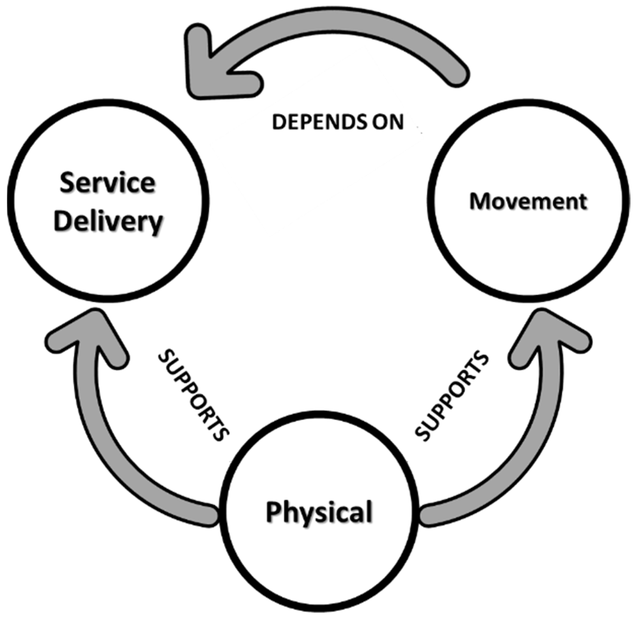
2.1. Circulating and Ecological Sphere (CES) and Rural–Urban Linkages

The concept of CES was introduced by the Japanese government in 2018 to synergize the existing efforts for resilience and sustainability in regions. CES was later promoted internationally to serve as a base for policy formulation [21]. The idea of CES represents a decentralized self-reliant society implementable at various scales. The concept adopts an integrated policy approach incorporating (a) a low-carbon society, (b) resource circulation and (c) living in harmony with nature based on rural–urban linkages as one of the key parameters [21]. Theoretically, CES encourages links between different spatio-sectoral dimensions to achieve its objectives [22]. Although being geographically dispersed and discretely governed, urban and rural areas are recognized to be closely associated with each other through diverse spatial linkages and sectoral interdependencies [23]. These linkages could be defined as symbiotic flows occurring between urban areas and their surrounding rural hinterlands including, but not limited to, people, goods, waste, finance or information [24,25,26]. In essence, the urban areas can be perceived as nodes offering services, communication technologies, knowledge networks and an overall association with national and global infrastructure [27], whereas rural areas can be perceived as the providers of food, water, energy, raw materials and other ecosystem services [28]. Although urban and rural areas are interdependent, rural areas are often observed to be lagging in their developmental trajectories as compared to their urban counterparts [29]. Migration from rural areas to the cities is one factor among several that leads to widening gaps in the prosperity of the two regions, particularly in developing countries [30]. A critical incentive offered by CES is that it encourages the creation of sustainable linkages between urban and rural regions based on gauging the existing flows, including migration [23]. It emphasizes that resources, whether goods, people, finances or knowledge, should be circulated at appropriate scales. In essence, CES proposes the establishment of new linkages between urban environments and their corresponding rural counterparts to promote the circulation of resources for realizing sustainable development goals and at the same time advocating appropriate levels of decentralization.
The importance of linkages has been well-acknowledged for offering a coordinated frame for development by UN-Habitat in 1976 in its first conference [31] and later by the Sustainability Development Goals [32] as well as the New Urban Agenda [33]. Recently, UN-Habitat proposed “enhanced prosperity of regions’’ as one of its four focus areas in its draft strategic plan, and to realize this objective, guiding principles for urban–rural linkages (URL GP 2019) [34] were formulated for advanced integrated territorial development. The framework for action encourages concrete policies and practices through locally grounded interventions. With the advent of the pandemic, UN-Habitat also published an issue briefly outlining relevant urban–rural linkage principles for COVID-19-relevant actions [35], indicating the role of linkages in managing pandemics. However, approaches for preparing a framework of development strategies and localized action plans based on these guidelines are still being investigated.

2.2. Rural–Urban Linkages and COVID-19: A Literature Overview

At the beginning of the pandemic, the epidemiological models predicted that COVID-19 would spread faster in urban metropolitan areas than in the rural areas [36]. In theory, lower population density should make the risk of COVID-19 transmission lower in rural areas. However, at a later stage, rural areas of India had a larger share of COVID-19 cases compared to urban areas, particularly during the months of March to June 2021 [37]. While the abysmal state of preparedness in urban areas was highlighted throughout the pandemic, a more distressing scenario could be observed emerging from the rural areas. A large part of this scenario could be attributed to mass migration in the first wave and the gradual revoking of the lockdowns in the second wave [13,17]. The governments were caught unprepared by the exodus from cities resulting from the imposition of lockdowns, compounded by the out-migration due to several other factors of economic and ecological distress—including extreme weather conditions and natural disasters [37]. At a regional level, migration or commuting is identified as one of the crucial links between urban and rural areas [30]. The flow of people as a resource from rural to urban areas benefiting both rural populations in terms of opportunities and income and urban population in terms of workforce availability can be understood while analyzing migration as a linkage parameter. The importance of migration as one of the critical links between rural and urban areas during the pandemic has also been highlighted through various case studies in India [17,38,39]. Through these studies, it was noted that migrants were essentially forced to return to their hometowns, either due to irregular income owing to pandemic-induced restrictions or safety concerns [40]. Throughout the literature related to COVID-19 and urban planning, authors have argued over the post-pandemic regional dynamics and whether the rural–urban systems will function as usual or are headed towards a new normal. Food insecurity was also noted to be one of the push factors triggering movement in certain areas [19,41], indicating that migration links are closely associated with supply chains. Although several other complex issues act as the drivers for regional development, understanding the underlying dynamics of migration and commute links reflects as imperative while planning for an effective response to the crisis [42].
Undoubtedly, COVID-19 imposed stress on the existing public health sector. Although the rapid spread of COVID-19 has often been associated with the unavailability of basic services and related infrastructure [43], access to higher-order services, particularly health-related services, remained one of the primary reasons prompting the relocation of rural residents to the urban limits [44]. The unavailability of health infrastructure, diagnostic centers and clinics in remote rural areas prompted convalescents to move to urban centers [40] where the state-run infrastructure was concentrated, thereby increasing the risk of spread. However, cases have been documented where affected people could not reach the facilities in time due to the unavailability of adequate health care and inaccessibility to transport routes or required transport options. As a response to this unavailability, the health care and the digital infrastructures have been widely discussed in the literature relating to COVID-19 and planning, emphasizing the emerging need for strengthening digital infrastructure to promote health care. The concepts of telehealth and mobile health care also started gaining recognition for better services in remote areas [45,46]. However, it primarily requires stronger physical connectivity down to the remote regions [42].
Another challenge while dealing with the pandemic was the supply chain. A large amount of literature related to COVID-19 and supply chains primarily centered around food security issues due to disrupted supply chains. The supply chain losses were largely dependent on the duration of lockdowns rather than the strictness [47]. However, it is apparent that supply chain disruptions due to the imposed lockdowns had far-reaching effects, particularly on agricultural markets. Several factors such as demand and supply fluctuations, logistics and infrastructure risks, biological and environmental risks and most importantly, financial risks, significantly impacted supply chains [48]. All these factors entail the interrogation of the nature of urban–rural interactions amidst crisis scenarios, particularly the dynamics underlying the highlighted three components of commute and migration, health-service capacities and transport infrastructures.

3. Materials and Methods

3.1. Case Study Area

This study was conducted at the tahsil level during the period of April 2021 to substantiate the emergent demands for spatial development [15] in regions. A tahsil is a local unit of administrative division, which comprises several towns and villages. For this study, Hingna tahsil, an emerging industrial suburb of Nagpur city, was selected to analyze its relationship with Nagpur city during the pandemic. One of the biggest tahsils located in the south-western part of Nagpur city, the Hingna tahsil covers an area of 942.79 sq. km. With a population of 242,198 and 28,603 households, the tahsil consists of 150 villages and seven census towns [49]. Figure 1 shows the location map of Hingna tahsil with respect to Nagpur city in Nagpur district (Maharashtra State, India).
The growth of Nagpur city is mainly observed toward the south and south-western parts owing to the presence of industries and the MIHAN Cargo Hub in the transitional area between Nagpur city and Hingna tahsil. The Maharashtra state highway, passing directly through the tahsil, and the National Highway 6 and 7, which is the broad-gauge railway line passing in the close vicinity of the tahsil, promotes rural–urban interactions, which is evident from the rapid development in this particular direction. Nagpur city largely receives agricultural commodities including cotton, soybean, ragi, jowar, gram followed by toor and wheat as well as industrial labor from Hingna. The concentration of census towns of Hingna tahsil near the boundaries of Nagpur city (Figure 1) is an indicator that significant interchanges are facilitated at the rural–urban boundaries of Hingna tahsil and Nagpur city.

3.2. COVID-19 Scenario in the Case Study Area

Despite the first active COVID-19 case being reported in (Kerala state) India around the first week of January 2020, Nagpur city reported its first case in the last week of March 2020m and the subsequent rise in cases peaked around the first week of September 2020. As commonly observed during the countrywide lockdowns, Nagpur too witnessed panic buying and mass migration [50,51,52]. A surge in cases remained unobserved in the rural areas of Nagpur district, including the villages of Hingna tahsil, during the first wave of the pandemic. However, with the imposition of the first lockdown, a decent number of migrants were observed leaving Nagpur city in the direction of Hingna tahsil. With the rising cases in the city, lockdowns continually put pressure on all the service providers as well as the enforcement authorities when people tried to stock essentials by violating the norms and needlessly venturing out [17,19]. At the same time, migrating daily wage workers and commuters presented yet another set of challenges. Thus, the response to the crisis was not only limited to managing lockdowns and health infrastructures but also making provisions for migrant workers during the first wave of the pandemic.
Around the last week of December 2020, despite the rising number of cases, the implementation of lockdowns had reasonably managed the surge [53], thereby encouraging governments to revoke the lockdowns. With the gradual phases of ‘unlocking’, the intrastate and interstate borders opened, and a steady rise in cases could again be observed [54], which peaked during the months of April and May 2021 and led Nagpur city, including the case study area, into the second wave of the pandemic. Hingna tahsil observed a steep rise in cases during this period. As travel and businesses started operating, increased mobility was noted as a major cause of rising COVID-19 cases [55,56] which was also evident in the case of Hingna tahsil as the influx of the asymptomatic ‘reverse migrants’ and commuters started returning to work [57].

3.3. Research Methods

3.3.1. Selecting Indicators

Building on the literature review in Section 2, the service delivery links, particularly health service delivery, physical links and movement links, emerged as critical while dealing with the pandemic and hence were focused on throughout the analysis in this paper. Past studies have also highlighted inter-relationships between the above-identified linkage parameters (Figure 2), indicating that the strong physical links between rural areas and parent cities form crucial components that support ease of movement as well as service delivery [58]. As was observed in the case study region, during pandemic times, service delivery also determined the frequency of movement.
For each identified parameter of linkages between rural and urban areas, a range of indicators were identified and assembled based on the modified ranking method [59], with values calculated or assigned at the village level. These values were then scaled and aggregated. The selected indicators represent important facets of the linkage parameters that have been identified, and their inter-relationships are elaborated upon in Figure 2 based on the experiences in Nagpur. Although the study was inevitably constrained by the availability of primary data due to the pandemic restrictions, the secondary database from the latest census report of 2011 was used as a support. Based on the three parameters of physical, movement and health service delivery links between rural and urban areas, four indicators and twelve sub-indicators, as presented in Table 1, were identified for analyzing rural dependence on cities.

3.3.2. Data Collection

The secondary data for this study were obtained from reputable sources such as the District Census Handbook (DCHB) 2011 [50] of Nagpur and the Open Government Database and was substantiated with the primary information gathered through telephonic interviews with the key informants from the gram (village) panchayats during the period of April 2021. The interviews were carried out using the purposive sampling method. These data, however, had limitations considering the (lower) availability of the key persons owing to the spread of pandemics in the concerned villages and the restrictions imposed thereby. Out of the 35 g panchayats and 20 clustered gram panchayats, a total of 32 were surveyed through telephonic interviews with key informants to gauge the situations during the pandemic under selected parameters.

3.3.3. Data Construction

The variables so obtained from the identified datasets were observed to have diverse values as well as measurement units. This posed a challenge while analyzing and comparing these variables. Therefore, normalizing the datasets to minimize errors resulting from divergent units was considered a prerequisite for the analysis. For this purpose, the study adopted the standardization method of proportioning the datasets at the village level and rescaling the variables to obtain comparable results from the available database. This kind of statistical rescaling method is widely used to generate comparable datasets. With the rescaled results, the relative index of each parameter was obtained, establishing the degree of rural dependence on urban areas. The critical datasets were then mapped with the ArcGIS version 10.5 software to understand the spatial component and its influence during the crisis.

4. Results

4.1. Secondary Data

The datasets were rescaled and proportioned with respect to the number of villages qualifying the respective criteria. For instance, the graph plotted in Figure 3 indicates the percent number of villages having direct access to transport and health infrastructure and the percent number of villages that needed to commute to gain access to the respective facilities. The component of literacy under technological capacity was rescaled based on the percent number of villages having a population literacy rate over 50% as a minimum qualifying criterion. After rescaling the data, it was observed that there was a typical distribution of sub-indicators. As is evident from Figure 3, more than 50% of the villages needed to commute for health-related concerns rather than education and employment due to the unavailability or no direct access to health care services. This was reaffirmed while analyzing direct access to health care infrastructures, wherein less than 25% of the villages had direct access to COVID-19 care health centers, and less than 20% of the villages had direct access to any alternative health care. On the contrary, adaptive infrastructures such as schools or community halls were conveniently available in more than 90% of the villages for the immediate quarantine of the people with COVID-19. Although direct access to pucca and semi-pucca roads was available for more than 50% of the villages, direct access to transport options such as buses and other para-transit options was available in less than 35% of the villages, which meant moving to cities or towns demanded access to private transport options. The analysis of technological capacity for knowledge dispersion and remote consultancy, work, etc., indicated that the availability of power supply, mobile and internet services as well as operational literacy was found in more than 75% of the villages.

4.2. Primary Survey Result

The primary surveys were mainly structured around the issues that were being faced at the village level regarding the provision of health care facilities and other losses incurred due to the pandemic as well as due to the consequent restrictions that were imposed. Out of the 32 telephonic interviews conducted with the key informants from different gram panchayats of Hingna tahsil, 27 reported that restrictions imposed due to the COVID-19 lockdowns had caused a lot of difficulties for the residents rather than the disease itself. Although in the beginning there were fewer cases, the administrative authorities were able to make adequate provisions for quarantine and mobile health care facilities. However, with the surge in cases, health care obligations and the financial necessities made it imperative for the residents to commute to nearby urban areas. Figure 4 represents the overall response from the key informants of different gram panchayats regarding the fundamental issues faced by the village residents during the pandemic.
Serious concerns were expressed regarding the loss of employment, business and farm produce followed by inadequate health care facilities and the need to accommodate incoming migrants with respect to quarantine shelters and similar facilities. The general relation of A leading to B and B leading to C could thus be substantiated and articulated as mentioned below:
Unavailability of services (A) → Commute (B) → Spread (C),
Implementation of lockdown (A) → restrictions on commute (B) → Loss (of life/income/etc.) (C)

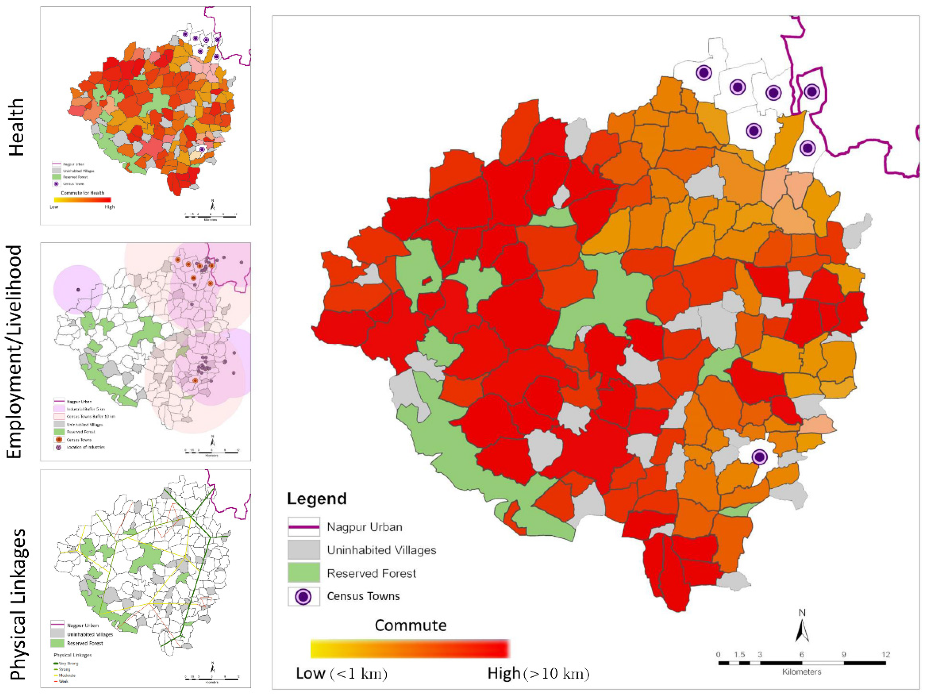
4.3. Spatial Analysis

The villages that absolutely needed to commute for any purpose were mapped as shown in Figure 5 based on the weightage assigned, as indicated in Table 2. The mapping was carried out using the weighted overlay method with the weights assigned based on the feedback from the key informants. It was observed that around 30% of the villages required the residents to commute more than 10 kms for work, to access health care or reach out to market intermediaries, and so on. Since the commute, which was not an issue during the pre-pandemic situation, was an essential part of their day-to-day lives and the implementation of lockdowns with the advent of COVID-19 disturbed the order of their routine activities, these areas incurred losses, not only in terms of lives but also financial losses. As the villages were overly dependent on the urban areas for medical facilities as well as for employment and to sell their produce, the implementation of lockdowns had exponential effects on the losses (Figure 4) that were incurred. As there were no intermediate service regions, the residents had to directly access the urban limits.
Based on the observations and expressed concerns, it was noted that there was a pronounced need to limit the excessive dependencies and the need for commuting, particularly in the events of crises such as the COVID-19 pandemic. Thus, there was a clear demand for local establishments facilitating emergency services. The concentration of industries and census towns along the boundaries of the city and Hingna tahsil generated business and employment, and services and facilities developed accordingly in these parts. Thus, residents in remote areas (constituting to around 45% of the villages in the tehsil) needed to commute to access the respective services. These villages reported issues related to loss of income due to the unavailability of direct access to markets as well as the lack of support infrastructure and suffered a severe setback during the lockdown period due to their dependence on these areas. Managing the rural dependencies on urban areas, not only from the perspective of health care but also income and employment, emerged as one of the critical findings at the end of this investigation.

5. Discussion

The COVID-19 pandemic was not merely a serious public health concern but a trigger for socio-economic crises. The plights of migrant laborers rendered jobless overnight due to the lockdown and subsequent mass exodus towards their native rural areas pushed the local as well as regional governments towards a humanitarian crisis. At the same time, the disruption in the supply chain leading to food and medicine shortages was yet another challenge to be dealt with. The pandemic reflected the unpreparedness of current health systems as well. The need to rethink the functioning of the existing rural–urban interactions to accommodate shocks has frequently been highlighted through different media including newspaper articles, general public interviews and research publications. Promoting digitalization and remote health-related consultation from urban areas for better correspondence with rural areas are among a few solutions that are being rigorously discussed. However, investigating the way these interactions are laid out necessitates researching alternate perspectives for the management of such crises. Towards this direction, the concept of CES that recognizes the importance of decentralized self-reliant societies at different scales, facilitating interchanges to foster holistic development in a region, can potentially be a valid approach. The key findings through this research were that (1) although stronger rural–urban linkages foster development, they also stimulate a higher level of dependencies, which during such emergencies are not necessarily desirable. (2) It was recognized that the organization of links between rural and urban areas may notably influence the order of rural functionality. For instance, establishing nodes within a cluster of villages could enable hierarchy in the rural–urban transect. These nodes could then be selectively diverted or deactivated in the event of an emergency. (3) It could also be understood that the performance of linkages may have a significant impact on self-reliance at the local level. This means that the more access and connectivity there is, the less self-sufficiency there is.
The linkages between urban and rural areas are often dynamic, and the recent pandemic proved that the nature of interactions varies depending on the circumstances. Therefore, novel approaches for sustaining, channeling, organizing and conditioning these rural–urban links need to be explored to manage the interdependencies between urban areas and their rural counterparts. This could be achieved by dispersing the centralized functions, in this case, into distinct areas which do not have direct access to the respective services. Such nodes would establish the said hierarchy wherein a cluster of villages can access the respective nodes to avail the emergency services and the node could be directly connected to the nearby towns or the city for higher-order services. Such nodes can facilitate health care units, markets, financial institutions, trade and education centers as well as intermediate repository establishments such as godowns, warehouses, and so on. This would encourage the easy monitoring as well as the efficient management of links, thereby paving a way for smoother transitions during the events of a crisis.
As recommended by the Urban–Rural Linkage Guiding Principles [34] and supported by the principles of CES, the potential of small and medium towns can be harnessed to act as mediators between villages and cities. Decentralization at the local level to manage resources could be utilized to achieve effective development transitions. The capacities of intermediate towns to act as nodes for response and coordination could be developed. These towns can also be developed as trade and education hubs with markets and recreational facilities. Smaller belts of land could be acquired and developed with the help of private role players. Ensuring an uninterrupted supply of power, clean water, quality road infrastructure and transport options along with appropriate telecommunication systems, as in the case of Hingna tahsil, such clusters may attract investments through incentives. From the point of view of urbanization, service clusters may have the potential to provide attractive alternative destinations for city-bound rural migrants as well. Such nodes not only serve as service intermediaries but also create employment opportunities leading to lesser strain on the primary cities, thereby alleviating urban poverty. At the same time, they are likely to be more intimate with the rural areas and therefore can play a critical role in reducing the overall rural poverty as well.
The approach to post-crisis ‘recovery’ is rooted in the assertion that societies have the capacities to determine the merits and degrees of returning to the previous state. This study advances the theory that adopting the principles of CES for post-pandemic development can offer a holistic approach to overall regional development. Although theoretically incorporating the concept appears to be a viable solution, it entails high levels of participation across all stakeholders to have a clearer understanding and a common agreement on choices of returning or proceeding to a new normal. Further, development programs have massive, long-lasting impacts and therefore need to be meticulously planned to ensure desired social and economic benefits while strengthening the existing systems to deal with future shocks. As reported by OECD [60], post-pandemic planning requires the generation of co-benefits for social equity, environment and human health. The literature regarding the COVID-19 and urban planning has often emphasized long-term infrastructure investments in digital as well as health care infrastructure in remote areas, which may also support rural development and advance bi-directional flows through rural–urban links. In a way, the pandemic has also reiterated the importance of a decentralized and self-reliant society. Amidst crises such as the pandemics, a decentralized spatial layout with manageable interactions may prove more effective than the existing layouts. However, further research in this area needs to be conducted to support this perception. Since the scope for this study was limited to these three elements, other elements of linkages have not been entirely explored and can be looked at as a way forward. At the same time, only the rural dependencies and impacts have been emphasized and explored in this paper; urban issues also need to be investigated through the lens of linkages. Although the study is specific to the COVID-19 pandemic, it presents an approach that can be tailored and adopted for various other regional-scale emergencies.

6. Conclusions

Every major crisis brings opportunities to rethink the structure of a system and make it more resilient to future shocks. This research asserts the notion that post-pandemic planning would call for the realignment of rural–urban interactions and the recognition of the importance of administration at the lowest level, both encouraged through the CES. Although CES exhibits tremendous potential for post-pandemic development, addressing the challenges related to critical service enhancement in peri-urban and rural regions still needs to be researched. One of the key findings from this research was that strong rural–urban linkages encourage more dependencies of rural areas on the city, and during emergencies such as pandemics, severe reliance on urban amenities and facilities proves undesirable. Ideally, diffusing the urban–rural binary with effective rural–urban linkages for an integrated development appears to be an archetypal solution. However, achieving this goal is an intensive task with respect to time as well as resources. Contrarily, managing linkages by maintaining a certain degree of hierarchy and re-directing the flows, particularly during times of crises such as the COVID-19 pandemic, emerges as a feasible solution. Thus, CES emerges as an approach to materializing the management of rural–urban linkages. This was also demonstrated through the case study presented in this paper.
Regional development approaches and urban planning models have not yet fully evolved in the context of pandemics, while the need for the same has been highlighted through several studies. Such attempts are also not evident in the case of cities in developing countries. This article, therefore, is a unique attempt in that direction by proposing an alternative approach to the provision of services at urban and regional levels to effectively respond to emergency scenarios through spatial planning. Although the idea of decentralization has been reiterated in the context of managing linkages between rural and urban areas, the provision of intermediate service clusters for developing a seamless continuum between the urban and rural areas calls for a more detailed investigation which can be looked at as the future scope of this study. As it is said, ‘Diseases shape cities’ and some of the most iconic developments in urban planning and management systems such as ‘sanitation’ were developed in response to public health crises of cholera outbreaks. Similarly, COVID-19 is also likely to leave an enduring mark on the present systems.

Author Contributions

All authors were involved in conceptualization, investigation, visualization, methodology and writing—review and editing; formal analysis and software, S.J. and B.M.; writing—original draft preparation, S.J. and S.D.; validation, resources, supervision, project administration and funding acquisition, S.D. and B.K.M. All authors have substantially contributed to the development of this manuscript. All authors have read and agreed to the published version of the manuscript.

Funding

This study is supported by the strategic research fund of the Institute for Global Environmental Strategies (IGES).

Institutional Review Board Statement

Not applicable.

Informed Consent Statement

Informed consent was waived as no personal information was collected from respondents and only general opinion survey was conducted.

Data Availability Statement

Not applicable.

Acknowledgments

The authors would like to thank IGES for supporting the study and also the key informants of the selected case study area for their cooperation during the entire study. The authors would like to express sincere gratitude to Rajarshi Dasgupta for making valuable contributions in refining the overall flow of the manuscript, literature, and reference material presented in the study as well as for the English language check.

Conflicts of Interest

The authors declare no conflict of interest.

References

  1. Fong, M.W.; Gao, H.; Wong, J.Y.; Xiao, J.; Shiu, E.Y.C.; Ryu, S.; Cowling, B.J. Non-Pharmaceutical measures for pandemic influenza in non-healthcare settings social distancing measures. Emerg. Infect. Dis. 2020, 26, 976–984. [Google Scholar] [CrossRef] [PubMed]
  2. Ogen, Y. Assessing nitrogen dioxide (NO2) levels as a contributing factor to coronavirus (COVID-19) fatality. Sci. Total Environ. 2020, 726, 138605. [Google Scholar] [CrossRef] [PubMed]
  3. World Health Organization (WHO) Press Director-General’s Opening Remarks at the Media Briefing on COVID-19—11 March 2020. Available online: https://www.who.int/director-general/speeches/detail/who-director-general-s-opening-remarks-at-the-media-briefing-on-COVID-19---11-march-2020 (accessed on 12 February 2022).
  4. Jha, S.; Goyal, M.K.; Gupta, B.; Gupta, A.K. A novel analysis of COVID-19: Risk in India incorporating climatic and socioeconomic factors. Technol. Forecast. Soc. Change 2020, 167, 120679. [Google Scholar] [CrossRef]
  5. World Health Organization. Considerations in Adjusting Public Health and Social Measures in the Context of COVID-19: Interim Guidance. Available online: https://apps.who.int/iris/bitstream/handle/10665/331773/WHO-2019-nCoV-Adjusting_PH_measures-2020.1-eng.pdf (accessed on 23 March 2022).
  6. Wasdani, K.P.; Prasad, A. The impossibility of social distancing among the urban poor: The case of an Indian slum in the times of COVID-19. Local Environ. 2020, 25, 414–418. [Google Scholar] [CrossRef]
  7. Paital, B.; Das, K.; Parida, S.K. Inter-national social lockdown versus medical care against COVID-19 a mild environmental insight with special reference to India. Sci. Total Environ. 2020, 728, 138914. [Google Scholar] [CrossRef] [PubMed]
  8. Sharma, S.; Zhang, M.; Anshika, G.J.; Zhang, H.; Kota, S.H. Effect of restricted emissions during COVID-19 on air quality in India. Sci. Total Environ. 2020, 728, 138878. [Google Scholar] [CrossRef] [PubMed]
  9. Wang, P.; Chen, K.; Zhu, S.; Wang, P.; Zhang, H. Severe air pollution events not avoided by reduced anthropogenic activities during COVID-19 outbreak. Resour. Conserv. Recycl. 2020, 158, 104814. [Google Scholar] [CrossRef]
  10. Eroğlu, H. Effects of Covid-19 outbreak on the environment and renewable energy sector. Environ. Dev. Sustain. 2021, 23, 4782–4790. [Google Scholar] [CrossRef]
  11. Tajani, F.; Liddo, F.D.; Guarini, M.R.; Ranieri, R.; Anelli, D. An assessment methodology for the evaluation of the impacts of the COVID-19 pandemic on the Italian housing market demand. Buildings 2021, 11, 592. [Google Scholar] [CrossRef]
  12. UN Habitat Pandemic Response Plan. Available online: https://unhabitat.org/un-habitat-covid-19-response-plan (accessed on 12 December 2020).
  13. Infante, S. India’s Coronavirus Migration Crisis. 2020. Available online: https://daily.jstor.org/indias-migration-crisis/ (accessed on 18 March 2022).
  14. Bock, B.; Duncan, J. Rural-Urban Relations in Times of COVID-19, Rural Sociology Wageningen University. 2020. Available online: https://ruralsociologywageningen.nl/2020/04/20/rural-urban-relations-in-times-of-COVID-19/ (accessed on 24 March 2022).
  15. Leach, M.; MacGregor, H.; Scoones, I.; Wilkinson, A. Post-pandemic transformations: How and why COVID-19 requires us to rethink development. World Dev. 2020, 123, 105233. [Google Scholar] [CrossRef]
  16. Ostby, G. Rural-urban migration, inequality and urban social disorder: Evidence from African and Asian cities. Confl. Manag. Peace Sci. 2015, 33, 491–515. [Google Scholar] [CrossRef]
  17. Sinha, R.K. Impact of COVID-19 on Rural India; Kalpaz Publication: New Delhi, India, 2020; pp. 1–12. ISBN 978-93-5324-311-1 (PB). [Google Scholar]
  18. Sukhwani, V.; Shaw, R. Urban–rural linkages and their implication to human security in pandemic time. In Global Pandemic and Human Security; Shaw, R., Gurtoo, A., Eds.; Springer: Singapore, 2020. [Google Scholar] [CrossRef]
  19. Sukhwani, V.; Deshkar, S.; Shaw, R. COVID-19 lockdown, food systems and urban-rural partnership: Case of Nagpur, India. Int. J. Environ. Res. Public Health 2020, 17, 5710. [Google Scholar] [CrossRef] [PubMed]
  20. Barca, F.; McCann, P.; Rodríguez-Pose, A. The case for regional development intervention: Place-based versus place-neutral approaches. J. Reg. Sci. 2012, 52, 134–152. [Google Scholar] [CrossRef]
  21. MOEJ (Ministry of Environment of Japan). The Basic Environmental Plan. 2018. Available online: https://www.env.go.jp/policy/kihon_keikaku/plan/plan_5/attach/ref_en-02.pdf (accessed on 21 March 2022).
  22. Skea, J.; Nishioka, S. Policies and practices for a low-carbon society. Clim. Policy 2008, 8 (Suppl. 1), S5–S16. [Google Scholar] [CrossRef]
  23. Ortiz-Moya, F.; Kataoka, Y.; Saito, O.; Mitra, B.K.; Takeuchi, K. Sustainable transitions towards a resilient and decentralised future: Japan’s Circulating and Ecological Sphere (CES). Sustain. Sci. 2021, 16, 1757. [Google Scholar] [CrossRef]
  24. Tacoli, C. Rural–urban interactions: A guide to the literature. Environ. Urban 1998, 10, 147–166. [Google Scholar] [CrossRef]
  25. Tacoli, C. The links between urban and rural development. Environn Urban 2003, 15, 3–12. [Google Scholar] [CrossRef] [Green Version]
  26. Tacoli, C. Small Towns, Rural-Urban Linkages, and Regional Development. 2017. Available online: https://www.urbanet.info/rural-urban-linkages/ (accessed on 14 March 2022).
  27. Berdegué, J.A.; Carriazo, F.; Jara, B.; Modrego, F.; Soloaga, I. Cities, territories, and inclusive growth: Unraveling urban–rural linkages in Chile, Colombia, and Mexico. World Dev. 2015, 73, 56–71. [Google Scholar] [CrossRef] [Green Version]
  28. Jennings, S.; Cottee, J.; Curtis, T.; Miller, S. Food in an urbanised world: The role of city region food systems in resilience and sustainable development. In Proceedings of the Report on Food in an Urbanized World Conference, London, UK, 4 February 2015; Available online: http://www.fao.org/fileadmin/templates/FCIT/documents/Food_in_an_Urbanised_World_Report_DRAFT_February_2015.pdf (accessed on 21 March 2022).
  29. Ohlan, R. Rural transformation in india in the decade of miraculous economic growth. J. Land Rural. Stud. 2016, 4, 188–205. [Google Scholar] [CrossRef]
  30. Imai, K.; Malaeb, B. Asia’s Rural-Urban Disparity in the Context of Growing Inequality. Part of Research Series by International Fund for Agricultural Development (IFAD). 2018. Available online: https://www.ifad.org/documents/38714170/40704142/27_research.pdf/86ff7619-8814-48d0-a232-fc694fcc55ce?eloutlink=imf2ifad (accessed on 13 February 2022).
  31. UN-Habitat Conference 1. Available online: https://www.un.org/en/conferences/habitat/vancouver1976 (accessed on 21 March 2022).
  32. Sustainability Development Goals. 2015. Available online: https://sdgs.un.org/goals/goal11 (accessed on 23 April 2022).
  33. New Urban Agenda. 2016. Available online: https://habitat3.org/wp-content/uploads/NUA-English.pdf (accessed on 21 May 2022).
  34. UN-Habitat, Urban-Rural Linkages Guiding Principles (URL GP), a Framework for Action to Advance Integrated Territorial Development. 2019. Available online: https://unhabitat.org/sites/default/files/2020/03/url-gp-1.pdf (accessed on 4 May 2022).
  35. UN-Habitat Issue Brief, COVID-19 through the Lens of Urban Rural Linkages—Guiding Principles and Framework for Action (URL-GP). 2020. Available online: https://unhabitat.org/sites/default/files/2020/07/issue_brief_covid-19_through_the_lens_of_urban_rural_linkages_web_revised.pdf (accessed on 18 April 2022).
  36. Stier, A.; Berman, M.; Bettencourt, L. COVID-19 Attack Rate Increases with City Size. 2020. Available online: http://arxiv.org/abs/2003.10376 (accessed on 5 January 2022).
  37. Center for Science and Environment Report, Rural India Worst Hit by Second Wave Compared to Urban Centres. 2021. CSE’s New Data Compendium. Available online: https://www.cseindia.org/world-environment-day-special-10834 (accessed on 10 March 2022).
  38. Sahni & Aulakh. Impact of COVID-19 on Rural Migrants in India; Kalpaz Publication: New Delhi, India, 2020; pp. 29–39. ISBN 978-93-5324-311-1 (PB). [Google Scholar]
  39. Goud. Impact of COVID-19 on Indian Migrant Workers in the Gulf Countries; Kalpaz Publication: New Delhi, India, 2020; pp. 40–51. ISBN 978-93-5324-311-1 (PB). [Google Scholar]
  40. Khanna, A. Impact of migration of labour force due to global COVID-19 pandemic with reference to India. J. Health Manag. 2020, 22, 181–191. [Google Scholar] [CrossRef]
  41. Smith, M.D.; Wesselbaum, D. COVID-19, food insecurity, and migration. J. Nutr. 2020, 150, 2855–2858. [Google Scholar] [CrossRef]
  42. Ravetz, J.; Fertner, C.; Sick-Nielsen, T. The Dynamics of peri-urbanization. In Peri-Urban Futures: Scenarios and Models for Land-Use Change in Europe; Springer: Berlin/Heidelberg, Germany, 2013; pp. 13–44. ISBN 978-3-642-30528-3. [Google Scholar]
  43. Mishra, S.V.; Gayen, A.; Haque, S.M. COVID-19 and urban vulnerability in India. Habitat Int. 2020, 103, 102230. [Google Scholar] [CrossRef]
  44. Mitra, A.; Murayama, M. Rural to urban migration: A district-level analysis for India. Int. J. Migr. Health Soc. Care 2009, 5, 35–52. [Google Scholar] [CrossRef] [Green Version]
  45. Meyer, C.; Becot, F.; Burke, R.; Weichelt, B. Rural telehealth use during the COVID-19 pandemic: How long-term infrastructure commitment may support rural health care systems resilience. J. Agromedicine 2020, 25, 362–366. [Google Scholar] [CrossRef]
  46. Patel, P.D.; Cobb, J.; Wright, D.; Turer, R.; Jordan, T.; Humphrey, A.; Kepner, A.L.; Smith, G.; Rosenbloom, S.T. Rapid Development of Telehealth Capabilities within Pediatric Patient Portal Infrastructure for COVID-19 Care: Barriers, Solutions, Results. J. Am. Med. Inform. Assoc. 2020, 27, 1116–1120. [Google Scholar] [CrossRef] [PubMed]
  47. Guan, D.; Wang, D.; Hallegatte, S.; Davis, S.J.; Huo, J.; Li, S.; Bai, Y.; Lei, T.; Xue, Q.; Coffman, D.; et al. Global supply-chain effects of COVID-19 control measures. Nat. Hum. Behav. 2020, 4, 577–587. [Google Scholar] [CrossRef]
  48. Sharma, R.; Shishodia, A.; Kamble, S.; Gunasekaran, A.; Belhadi, A. Agriculture supply chain risks and COVID-19: Mitigation strategies and implications for the practitioners. Int. J. Logist. Res. Appl. 2020, 23, 1–27. [Google Scholar] [CrossRef]
  49. District Census Handbook of Nagpur. 2011. Available online: https://censusindia.gov.in/2011census/dchb/DCHB_A/27/2709_PART_A_DCHB_NAGPUR.pdf (accessed on 14 January 2022).
  50. Biswas, S. Coronavirus: India’s Pandemic Lockdown Turns into a Human Tragedy. 2020 The BBC. Available online: https://www.bbc.com/news/world-asia-india-52086274 (accessed on 14 January 2022).
  51. Hrishikesh, S. Coronavirus Lockdown: As Indians Begin Panic Buying, Govt Clarifies. 2020 HuffPost News. Available online: https://www.huffingtonpost.in/entry/coronavirus-lockdown-modi-speech-food-groceries_in_5e7a3229c5b6f5b7c54bc90e (accessed on 14 January 2022).
  52. Inamdar, V.; Thusoo, S. COVID-19 Reverse Migration Calls for Long-Term Rural Development Planning. 2020. Available online: https://thewire.in/rights/COVID-19-reverse-migration-long-term-rural-development-planning (accessed on 12 March 2022).
  53. National Disaster Management Authority. COVID-19 Impacts and Responses: The Indian Experience. 2020. Available online: https://ndma.gov.in/sites/default/files/PDF/COVID-19/COVID-19-Indian-Experience.pdf (accessed on 15 March 2022).
  54. Tiwary, D. Unlock 2: More Flights, Trains, but no Schools and Colleges till July 31. The Indian Express. 2020. Available online: https://indianexpress.com/article/coronavirus/unlock-2-guidelines-july-coronavirus-6482179/ (accessed on 21 March 2022).
  55. Saha, J.; Chauhan, P. Lockdown and unlock for the COVID-19 pandemic and associated residential mobility in India. Int. J. Infect. Dis. 2002, 104, 382–389. [Google Scholar] [CrossRef]
  56. Virmani, A. India’s Second COVID-19 Wave. 2020. Egrow Working Paper. Available online: https://egrowfoundation.org/research/indias-second-COVID-19-wave/ (accessed on 18 January 2022).
  57. Arya, S. Vidarbha also Sees Influx of Migrant Labourers. 2020. Available online: https://timesofindia.indiatimes.com/city/nagpur/vidarbha-also-sees-influx-of-migrant-labourers/articleshow/74939056.cms (accessed on 12 February 2022).
  58. Avery, L.J.; Regmi, M.B.; Joshi, G.R.; Choudhury, R.; Mohanty, C. Rural-Urban Connectivity in Achieving Sustainable Regional Development, Background paper for the Intergovernmental Tenth Regional Environmentally Sustainable Transport (EST) Forum in Asia. 2017. Available online: https://www.uncrd.or.jp/content/documents/5048Final%20Background%20Paper%20for%20EST%20Plenary%20Session%203%20(1)-rev-3.pdf (accessed on 21 March 2022).
  59. Organisation for Economic Co-operation and Development, Handbook on Constructing Composite Indicators, Methodology and User Guide. 2008. Available online: https://www.oecd.org/sdd/42495745.pdf (accessed on 14 January 2022).
  60. Organisation for Economic Co-operation and Development, Tracking Progress through Pertinent, Comparable and Timely Data. 2020. Available online: http://www.oecd.org/coronavirus/en/themes/green-recovery (accessed on 14 January 2022).
Figure 1. Location of Hingna Tahsil in Nagpur.
Sustainability 14 09386 g001
Figure 2. Relationship between various linkage parameters.
Sustainability 14 09386 g002
Figure 3. Performance of sub-indicators (source: DCHB [50] Nagpur, Census 2011).
Sustainability 14 09386 g003
Figure 4. Critical issues faced by the villagers (based on key-informant interviews).
Sustainability 14 09386 g004
Figure 5. Commute map at village level (based on DCHB 2011 [41] and primary surveys).
Sustainability 14 09386 g005
Table 1. Indicators for analyzing rural dependence on cities during a pandemic.
IndicatorSub-Indicator (Variables)Criteria
Significance of interactions
(movement links)
Commute for education purposes (high pre-pandemic frequency) Number of villages without direct access to schooling beyond primary schools
Commute for work/employment purposes (high pre-pandemic frequency)Number of villages with industry within 5 km, number of villages selling off produce in urban limits
Commute for health purposes (high frequency during pandemic)Number of villages without direct access to higher-order health care facilities
Technological capacity
(influencing movement)
Mobile and internet servicesAvailability
Power supplyElectricity for domestic, commercial and agricultural use
Literacy rateNumber of villages with a minimum 50% literate population
Transport infrastructure options
(physical links)
Connectivity to pucca roadsNumber of villages with direct access
Connectivity to semi-pucca roadsNumber of villages with direct access
Access to public transport optionsNumber of villages with direct access
Health infrastructure
(service links)
COVID-19 care health infrastructure (allopathic)Number of villages with direct access
Substitute health care infrastructure (homeopathic/ayurvedic)Number of villages with direct access
Adaptive infrastructure (schools/hotels)Number of villages with direct access
Table 2. Weights assigned for overlay (based on inputs from the key informants).
CategoryPriorityRank
Health41.50%1
Employment/livelihood36.30%2
Physical links23.20%3
Publisher’s Note: MDPI stays neutral with regard to jurisdictional claims in published maps and institutional affiliations.

