
How to Activate the Value in Existing Stocks through Adaptive Reuse: An Incremental Architecture Strategy


1
Department of Architecture and Design, Politecnico di Torino, 10125 Turin, Italy
2
Interuniversity Department of Regional and Urban Studies and Planning (DIST), Politecnico di Torino, 10125 Turin, Italy
*
Author to whom correspondence should be addressed.
Sustainability 2022, 14(9), 5514; https://doi.org/10.3390/su14095514
Submission received: 7 April 2022
/
Revised: 30 April 2022
/
Accepted: 2 May 2022
/
Published: 4 May 2022
(This article belongs to the Special Issue Sustainable Reuse of Historical Buildings)
Abstract
:This paper illustrates a methodology for the remediation of polluted ex-industrial sites that considers the adaptive remediation and reuse of previously productive buildings and is structured in an incremental strategy. The main features of an adaptive reuse intervention are generally considered: low investment; high heritage awareness; urban identity; strong community engagement; and green concern. These characteristics are only partially compatible with the transformation of brownfields, mainly because of their usual size of the area, as it would require a large initial investment to purchase and convert the entire asset. To tackle this issue, we are proposing an incremental strategy that starts from the design process and is based on three main principles: (i) keeping and reusing as much of the existing buildings and facilities as possible; (ii) drawing the masterplan layout according to the pollutants, their zone distribution and the remediation techniques; and (iii) increasing public interest towards the area, attracting investors and stimulating a mechanism to rise the market value of the real estate property. The incremental strategy is illustrated through a project to reactivate an abandoned industrial area in Venice, Italy.
1. Introduction
Starting from Jane Jacobs’ statement “New ideas must use old buildings” [1], we can state that adaptive reuse is a diffused practice for architecture and urban design nowadays around the world. The tools and methods of this practice are analysed and discussed using a wide range of scientific literature that mostly point out the straightness rather than the weaknesses of this approach [2,3,4]. Reuse is a practice that is also spreading radically in countries such as China that are forcing the building construction market but have also recently been reflecting the shift from primarily new construction to circular economy processes where the recycling of materials and the reuse of existing buildings are part of this dynamic. As architecture requests face different needs that are in continuous evolution, re-use presents itself as an operational tool that reconciles the need to not disperse the embodied energy and to attribute value in terms of durability, sustainability and adaptability to what is underused, dismissed or abandoned; a value—a legacy—becomes an opportunity for development and innovation, even with scarce financial resources [3,5]. In our research, we are focusing attention on the adaptive reuse of abandoned and polluted sites with a strong industrial legacy, also called brownfields.
During this time, industries have diffusely built new spaces to create value. Due to the introduction of new technologies, changes in the market, globalisation and so on, several plants had to turn off their operations, leaving areas abandoned. Today, these abandoned areas are often polluted due to the industrial processes which were once active. The problem related to abandoned and polluted settlements is a current crucial issue due to the difficulties in requalifying these sites, which present complex environmental, infrastructural and economic problems. These areas need to be environmentally remediated but at the same time demand the reactivation of the existing buildings and the creation of new spaces and links with the surrounding areas. Despite these multiple demands, the approach to the requalification of abandoned and polluted areas has so far been mainly sectorial, intending the concept of “remediation” as completely separated from that of “re-development”.
This paper intends to answer the following research question: how can an intervention strategy be defined on a former industrial area that allows for the maximum reuse of the existing buildings and a minimum initial investment through a targeted use of the project?
To answer to this question, we define a methodology that—supported by multidisciplinary competencies and integrating engineering, architectural and designing skills and economic evaluation—seeks the requalification of polluted and abandoned industrial sites using an adaptive reuse and remediation approach under a holistic and integrated framework [6]. Beyond the integrated dimension of this methodology, it is also worth mentioning its adaptive dimension: an adaptive reuse and remediation approach considers the possibility that, in a polluted site, different areas need different types of remediation depending on the location and state of the pollutants. For this reason, it is likely that the remediation timing could be different for the areas. Adaptive reuse allows for the dynamic transformations of the sites and for the maximum exploitation of the area, taking into account the state of the remediation and construction operations to achieve the desired outcome. Therefore, the final aim will be attained through incremental steps in order to start revitalising the site and to also produce an incremental economic return. The reconstruction of the urban and industrial history of the site led to a complete understanding of the complex overlay of the materials and processes leading to the current situation. This was the basis for the definition of a complete, incremental and holistic urban masterplan that progressively approached the transformation of the site, harmonised the clean-up processes and settlement phases in order to minimise the costs and to preserve and reuse the heritage buildings and infrastructures, and inserted new architectures into the existing urban tissue. The economic evaluation proved that this approach leads to a relevant reduction in the site reclamation and construction costs, thus enhancing the feasibility of the urban regeneration already in the early process phases.
The methodology defined here was applied to an existing area, the Ex-Italgas Santa Marta industrial settlements in Venice, which is an abandoned and polluted site. In the past years, different regeneration projects have been proposed for this strategic site without appreciable outcomes.
In the city centre of one of the most well-known Italian historical cities, Venice, this case study, with its contradictions and complexities, is offering a perfect location for our research methodology, which is trying to offer a transformation scenario able to combine the valorisation of the abandoned urban landscapes and the post-industrial buildings with the reduced costs of intervention. “In contrast to the concept of innovation supposedly being produced by formal and technical prowess and individual creativity, adaptive reuse experiences show that innovation is the result of enduring social practices that are generated independently of architecture but reach their full potential if interpreted and enhanced by architecture” [3] (p. 171). The intervention strategy proposed and illustrated here, although not concretely implemented, was discussed with the site owner and the main public and private actors that could intervene in the area.
2. A Methodology for the Requalification of Polluted and Abandoned Industrial Sites
2.1. The Phases
In this paper, we foster a new integrated methodology for the requalification of a polluted an abandoned area that primarily focuses on understanding and planning the future use of the land and consequently adjusting the remediation process to preserve the existing built environment, thus linking the remediation of the site with its re-development. In this perspective, remediation is not considered as a mere elimination of pollutants and risk factors, but as the first step of an integrated strategy of urban regeneration.
The proposed methodology for the requalification of the polluted and abandoned industrial sites is articulated into four phases:
- the analysis of the area, which includes a survey of the condition of the existing abandoned buildings, a mapping of the pollutants present on the soil and buildings, a verification of the pre-existing projects and expressions of interest from public and private parties;
- the identification of the remediation map for the various parts into which the site can be divided according to the pollutants, and the identification of the different possibilities of use compatible with the relevant remediation;
- the development of an adaptive reuse project, integrated with the remediation actions and the hypotheses of the real estate valorisation of the area, identified starting from the appropriate market analysis and economic feasibility assessment;
- the construction of an incremental architecture and value creation strategy, subdivided into phases, adaptable according to the evolution over time of the crucial factors of the operation (an increase in the foundation value, a change in the image of the site, the reaction of the real estate market, etc.).
This article concentrates on illustrating the third and fourth phases, which constitute the most original aspect of our proposal.
2.2. Development of an Adaptive Reuse Project
It is known that the main aim of remediation is to protect people and the environment against potentially harmful effects deriving from the exposure to hazardous materials and agents. Specifically, remediation entails a series of actions to remove pollutants from soil, groundwater, surface water and sediments.
We can acknowledge at least two main kinds of reasons to perform the remediation of a site: ecological concerns and urban and economic concerns. Ecological concerns originated in the late 1970s and are linked with scientific studies and environmental activists. Urban and economic aspects are rooted in the transition from Fordism to post-Fordism, when industrialised cities had to face the problems generated by large industrial sites that were no longer active and were located in the core areas of cities.
Giving a quick look at how remediation principles are defined around the world, we note that a common benchmark to consider is the so-called Dutch standards, especially in countries where environmental laws are poorly developed. These standards were introduced after a scandal occurred in the redevelopment of the housing complex in [7] and focus on the pollutants’ concentrations in soil and groundwater.
On the other hand, to allow for a more comprehensive point of view, the Canadian approach was developed in the late 1980s. Its most relevant contribution is the division of remediation practices into two sequential steps: (i) analysis of the contaminants and their concentrations, and (ii) risk assessment. This approach has been developed by the Contaminated Sites Management Working Group and is strongly risk driven. The objective is to assess the risk for human health and for the natural environment considering land-use scenarios. It involves the identification of the contaminants, determining the potential exposure pathways and an estimation of the level of risk.
Conversely, the European Union never developed a common directive shared by member states, and each state has its own standards and laws to regulate the remediation of brownfields, taking into account their specific economic, social and environmental contexts.
In Italy, the main institutional body that controls and manages the situation of polluted areas is the Environment Ministry. Following the law 9 December 1998 n. 426, its internal organ, the ISPRA (the Italian acronym for: Institute for Environmental Protection and Research) has identified 39 industrial sites of national interest (SIN) that are in critical condition, covering 100,000 hectares. The Italian legislation sets a clear procedure that strongly resembles the risk-based Canadian approach and includes sequential stage-gate steps such as site identification and characterisation, risk assessment, the evaluation of different risk management strategies, the implementation of a selected management strategy, assessment and monitoring. However, remediation has been historically slowed down by difficulties that are mainly: economic (the cost of remediation increases and is not justified by the expected return in the current real estate market); social (questions usually arise on the actual usefulness and overall benefit of remediation); legal (long legal disputes are common to find the party responsible for the remediation); and technical (techniques and analyses are becoming more complicated).
2.3. Adaptive Re-Use—An Architectural Tool
In these last years, the reduced financial resources that followed the crisis of 2008 and now the new economic crisis—a consequence of the pandemic—have made this design practice increasingly widespread, also considering that the directives in Europe foresee zero soil consumption by 2050 and no net land take by 2050 [8].
This architectural project assumes the organisational role of the system and identifies decisive elements with a particular focus on the reuse of the space and detail that becomes architecture together with retrofitting and regulatory adaptation, transforms works that are supposedly based on technical adaptations into an opportunity for formal redefinition, and is capable of significant impacts on the territory.
In relation to the “Adaptive reuse” concept, according to [9], it is defined as “a revitalization strategy that employs a series of linked procedures to plan for, inventory, acquire, manage and reuse surplus or abandoned real estate”. This means that the existing buildings are no longer suitable for their purpose and that a new purpose must be defined by finding new values that are maximised by adapting the space. From an adaptive reuse perspective, the transformation of the site derives from a deep and careful analysis of the current conditions to minimise the need for new construction activities. On the other hand, an “Adaptive remediation” perspective also implies a deep knowledge of the site conditions in order to decide what kind of reuse should be adopted and to minimise the remediation cost, being equal, of course, to the level of safety. Adaptive remediation is strictly carried out together, in time and space, with an overall redevelopment plan.
The activity of adaptive reuse should follow some principles, as [10] said in 2007: it should perform the functions well for which they are redesigned; it should be lasting and adaptable to new uses; it should respond well to its surroundings and enhance its context; it should have a visual coherence and create ‘delight’ for users and passers-by; and it should be sustainable—there should be no polluting and it should be energy-efficient, easily accessible and have a minimal environmental impact. Re-use in many cases is a tool used to highlight the local identity of places and cities and is universally recognised as a sustainable action to save embodied energies [5,11,12,13,14,15]; it is a response to the need “to reconstruct” a disjointed and strongly diluted urbanised area and this becomes an opportunity to radically re-think abandoned buildings, brownfields and spaces awaiting transformation [5]. The approach suggested in 2011 by [16], highlighting the complex system of the implications that adaptive re-use carries, has been enriched by a toolkit of actions and strategies [3] to adopt in the process, connected to the adaptive re-use of a site not necessarily including buildings.
An adaptive reuse project can therefore have multiple benefits from an environmental, social and economic point of view. In relation to the environment, it must be underlined that reusing an existing building implies retaining its embodied energy to reduce the number of demolitions and, therefore, waste; furthermore, keeping the existing buildings reduces pressure on municipalities, preserves the urban environment and reduces urban sprawl. Considering the social benefits, the value of keeping the historical buildings alive can be underlined, considering their capability to create a link with the past and revitalise the surrounding neighbourhood. Of course, the social aspect goes on with the economic ones; maintaining a building also means reducing the costs for the population, the costs for infrastructure, the costs for new materials, and some studies have underlined that future generations will benefit from this approach by making the historical heritage accessible and adaptable. The economic aspects also regard the fact that, on one hand, for a developer who owns an old building, changing the uses and destination in an adaptive way could mean immediate liquidity through a cost reduction with respect to the new construction, and on the other hand, for the municipality, means obtaining more property taxes on the land.
The importance of improving the value of the historical buildings is acquired, but the bet is on the ordinary heritage, abandoned buildings and underused sites today, which are not subject to any restrictions (“Tutela” in Italy) and do not belong to any local or state list of protection representing a specific legacy of a city or a site to be re-designed with the multiple benefits that adaptive reuse can provide
Thus, adaptive reuse can be recognised as an operational tool which reconciles the need to not disperse the embodied energy and attributed value in terms of durability, sustainability and adaptability to what is underused, dismissed or abandoned: a value —a legacy—becomes an opportunity for development and innovation, even with scarce financial resources. We must remind individuals that the best project of adaptive reuse is the one that can better respect and retain the building features and, at the same time, can add the possibility of new value for the building [17].
2.4. Construction of an Incremental Architecture and Value Creation Strategy
The existence of underused or vacant buildings and spaces is a relevant phenomenon in contemporary cities [18,19,20]. These buildings embody a dormant asset that furthermore creates problems and degradation in the urban fabric [21]. The reality of several European cities shows how traditional forms of stimulating urban renewals (with respect to the financing of operations, ways to design and build the buildings and the urban planning legislation) no longer work. In the specific case of the polluted ex-industrial sites, the situation is even more difficult because of the heavy costs of remediation.
In this paper, we propose a methodology structured in steps to support the definition of the intervention strategies for activating the reuse operations of brownfields, with a low intensity of financial capital through a new culture of design.
To explain the temporal strategy to activate value in the existing stock, it is necessary to illustrate the different steps of the property development process. The process of real estate development consists of a series of different and consecutive steps, each of which presupposes the intervention of actors operating in the professional, business and administrative world, each with their own competences and roles.
The production process takes place over a period of time in which the various cost items are not only incurred at deferred moments in time but can be carried out by different subjects and actors intervening in the property market. A number of key figures can be clearly identified in this process: the figure of the developer, who commits to the transformation and invests with an expected return linked to the risk he/she bears; the figure of the manager of an activity, who must allow an income to be paid to the owner developer; and the Public Administration, who defines the rules by which the developer and manager transform and use the property.
First of all, there is an initial moment of the development of the area, in which the developer or entrepreneur selects the development opportunities then starts with an operation that can be of the "greenfield" type if it is a matter of new works to be realised, or of the "brownfield" type if it is a matter of works already realised or in progress. After that, the actual development of the property takes place, proceeding with all design and construction activities and managing the technical process until the buildings are completed. Once the asset is ready, it is operational in the marketplace and the product is marketed until it is sold and subsequently used; then, the investments and management decisions relating to the asset are made.
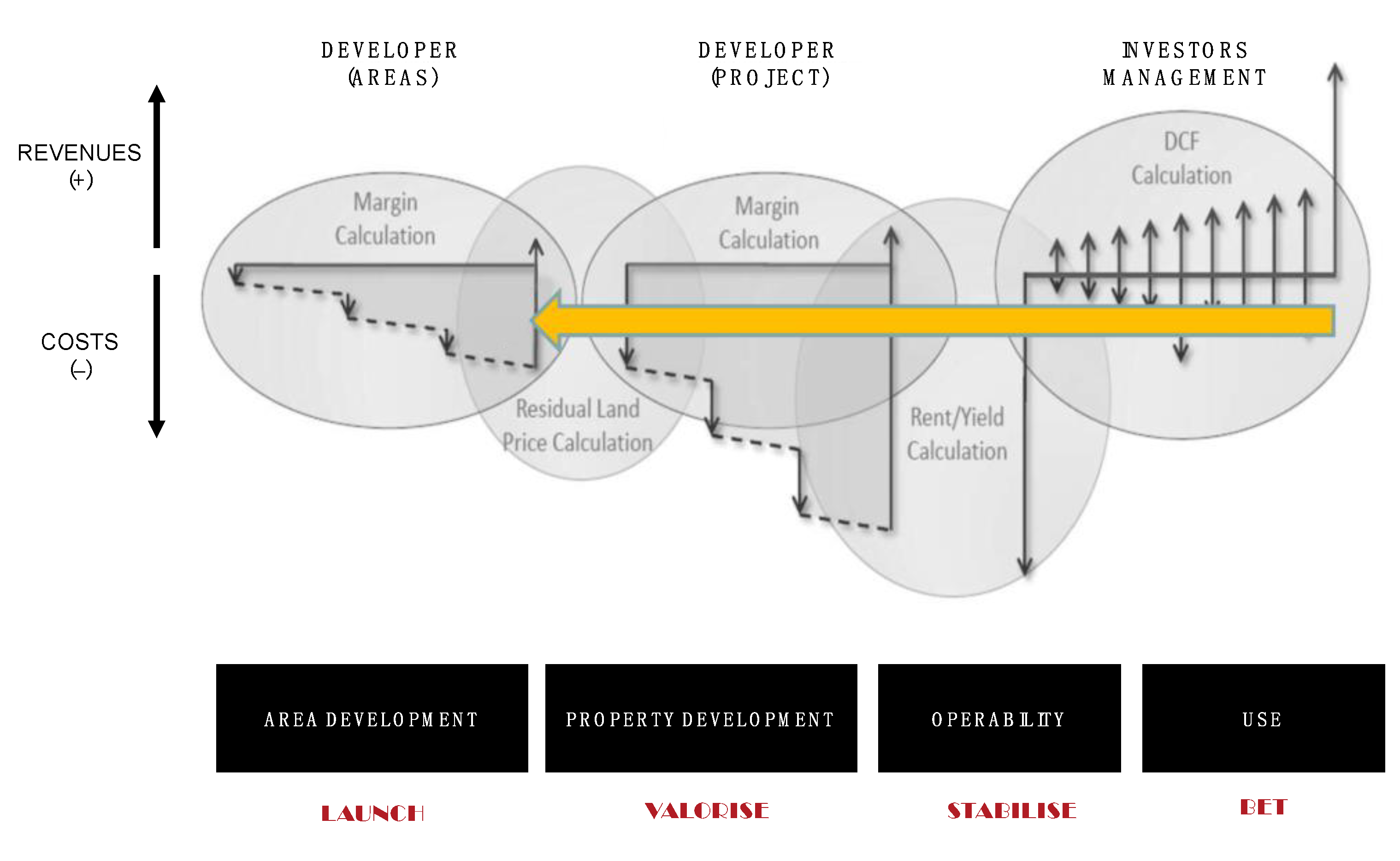
To better understand this process in general terms and then with reference to our case study of Venice, please refer to Figure 1.
The first phase concerns the developers’ search for areas or buildings to be transformed, estimating at an early stage the final value of the property (and often well in advance of the actual transformation of the real estate) to assess the actual profitability of the operation. There are valuation techniques that allow for this type of analysis to be carried out, one of the most widely used being Discounted Cash Flow Analysis [23].
Analysing what is shown in the graph, the downwards arrows appear primarily in the direction of the costs. This is because once the area has been purchased, there is first a series of costs and economic disbursements which correspond to some first essential operations for the development of the area (which are, for example, projects and authorisations, reclamation, which in the case of former industrial areas is a very important item, the infrastructural and urbanisation interventions in the area and so on). After that, for the operation to be feasible, it is obviously necessary for the developer to return the costs incurred as soon as possible with total revenues that have a certain margin. We refer here in the graph to the upward arrow, which corresponds to revenue. Revenues in the area development phase are linked to the sale or the concession of the areas themselves and to those who will be responsible for the project and construction (for the operation to be feasible and worthwhile for the developer of the areas, they must exceed in the amount of disbursements linked to the purchase of the area and its very first transformation).
In the development phase of the project, once the purchase of the area/existing building has been made, the developers oversee actually putting the property into operation, whether they are new constructions or renovations. There is then the realisation or redevelopment of the properties, depending on whether the previous development operation was linked to empty or already built-up areas. Additionally, at this stage, some costs have to be considered, represented by the downward arrows which concern all the phases of the development of the project, the actual construction and the realisation, up to the implementation of the finishes. Proportionally, the costs are expected to be much higher than in the previous phase, because in fact this is the phase where the bulk of the operation in concrete terms is realised. Even in this case, it is clearly important that the developer returns from the costs incurred with total revenues that have a profit margin compared to the expenses, so you can see that the upward arrow shows a revenue related to the operation of developing the properties. Revenues in this case are given by the sale to the investors or are rented to the managers of the properties that they themselves put in place.
Finally, investors and managers buy or manage properties from project developers, so in this case the main cost is the purchase of the property. After that, there are arrows distributed variously between the costs and revenues because they depend in part on rent, which increases or decreases according to inflation, the need for small works and investments, renovations and so on.
The price that the investor buys the property for or agrees to for the rent is given by the sum of these trends plus the expected return on the investment and is therefore defined from the calculation of the discounted cash flow. This reasoning is highlighted in the graph by the yellow arrow, i.e., the fact that these incomes and cash flows (that the finished property will give to the investor) actually go straight to determining the value of the land, which is therefore influenced by the final value of the property.
This means that, at a point in time at least a couple of years before the realisation and use of that property, the developer must be able to estimate what the profitability of the operation will be, i.e., what the investors’ expected revenues will be for that property which does not yet exist.
In this real estate development process, already characterised by numerous variables that are difficult to predict, there are additional risks in the case of the transformation of the former industrial areas. For this reason, four key actions are suggested for the valorisation of the existing stocks, related directly to the phases illustrated above and highlighted in red in Figure 1:
Launch. In the "area development" phase, the presence of more or less known pollutants can greatly vary the works and therefore the costs of reclamation to the point of making the real estate operation completely unfeasible. Often, the pollutants are not homogeneous in the area so it is essential to create a “contaminants map” to establish whether there are less polluted areas, in which it is possible to intervene earlier, to attract new investors, to change the image of the area and to create initial forms of revenue. It is therefore necessary to launch the first small operations (in terms of both investment and size in relation to the overall surface area of the site) which will change the perception of the area. Often the uses contemplated at this stage are cultural/recreational and temporary in nature [24,25,26].
Valorise. In the “property development” phase of the adaptive reuse approach, it is necessary to make the most of the existing buildings, not only in terms of the building typology but also, where possible, in terms of the character of the site. While respecting the original characteristics, it will be necessary to link the new contemporary history to a powerful memory. It is necessary to link the new design with the history of the abandoned buildings and the culture of the place where they stand in order to build the future on the past [27,28]. Reconnecting with the local history and culture of a place also makes it possible to enhance the professional figures already present in the area, with obvious economic benefits.
Stabilise. Between the “property development” phase and the “operability” phase, the value of the area should be stabilised with traditional uses: the highest-risk phase should already have been overcome so the new land and market value can be consolidated through longer-term uses similar to others already present in the surroundings;
Bet. Once in the use phase, one can also invest in the future with less ordinary uses, linked to the latest trends in the business world and beyond. It is necessary to investigate what attracts users, residents, entrepreneurs, innovators and possibly investors to set up successful and convincing projects. It is therefore necessary to ask and investigate what people want, what they fear and what they dream of. All this is conducted to renew attraction to the urban place by including quality services and products that attract users [27]. In this sense, the appropriate architectural design, carried out in the second phase, should allow for maximum flexibility, combining historical elements with innovation to attract a wide variety of users [29].
Obviously, to describe the wide spectrum of events constituting the processes of the redevelopment and enhancement of brownfield sites, which are often long-term evolutionary processes with objectives that, in most cases, need change completely over time, we must forcibly summarise and dispense with some nuances. In this sense, we suggest that Figure 1 be understood as a readable synthesis, accepting the inevitable inaccuracy of a synthetic view.
3. Applying the Methodology: Italgas in Venice
3.1. The Case Study
It is no coincidence that the area selected as a case study is located in Venice, a shrinking city caused by the depopulation of the lagoon area in favour of Mestre and other more accessible neighbouring municipalities.
The Ex-Italgas Santa Marta area (81,232 m2) is located on the Dorsoduro Island, namely the southwestern area of Venice inside the Santa Marta District (Figure 2).
It consists of some abandoned buildings and two gasometers that opened in 1907 and, at the beginning of the 19th century, mainly processed coal and coke. Later on, in the 1950s, the site was acquired by the Società Civile di illuminazione e gas of the city of Venice, which needed to expand its activity based on the increasing request of the market. The process of the transformation of raw materials stopped when the gas started to be bought from other countries (just after the 1950s); in the following years, the gradual dismission of the site was slow but continuous, leaving only some of the Italgas offices operative (Figure 3).
The area’s boundaries have different characters. In the south, there is a strip of social housing from the early 1900s, which are properties of ATER Venice: these structures should be considered in the project for the formal and functional relationships that will be established with the new settlements. In the northwest, along the Scomenzera channel where the boat stop of Santa Marta and the driveway to San Basilio is located, the area is closed by a street that is improperly used for parking and by the abandoned railroad tracks belonging to Ferrovie dello Stato, originally servicing the docks. In the east, the S. Maria Maggiore channel connects the area with the denser surroundings in the direction of Piazzale Roma.
The site is one of the few areas in Venice that can be reached by car; the train station and bus station are within walking distance and a public boat service stop is located on the western side of the area. This makes Santa Marta a unique location with great development potential in terms of the potential urban and economic impact. The University of IUAV is close to the site, located in the old cotton plant, and is a result of a successful adaptive reuse project that transformed the original docks building into a vibrant location, revitalising the entire neighbourhood.
3.2. Designing New Scenarios
Nowadays, the area presents a polluted field in which different projects have been proposed in the past without succeeding due to the lack of understanding of its complexity.
The main stakeholders involved in the process of transforming the area of the Santa Marta site are Snam, who owns the area; the Municipality of Venice, which is interested in obtaining a revitalisation of the city neighbourhood in terms of the environmental and social improvement; IUAV, located beside the site; and the local cooperative of citizens, who are interested in the transformation of the site considering the possible new activities that can reactivate local interest.
The different layers of the analysis of the site studied in the first part of the research identifies the environmental, economic, infrastructural and accessibility features. To be more precise, from an environmental point of view, which is significant in terms of the economic impact, the site was found to be polluted both in the saturated and the unsaturated soil, mainly with pollutants such as arsenic, heavy hydrocarbons, mercury, benzene, zinc and lead. The pollution of the site is significant in terms of the economic impact on remediation and on the population’s perception of the location, in the perspective of a partial transformation into residential units. The peculiar situation of the Santa Marta’s site in Venice, as we discussed in the previous section and which can be reached both by private boats and cars and by a strong public transportation system, offers multiple possibilities for innovative and valuable solutions for the regeneration of the entire area.
The methodology for the development of the area is a step-by-step process, combining the timing of the remediation, the new system of mobility connections, the buildings’ adaptive reuse, and the new constructions and uses of public and semi-public spaces, while overcoming the risks bound with pollution but at the same time trying to gain economic benefits.
After the pollutants analysis clarified that only heavy hydrocarbons and arsenic are dangerous to health, it was determined that removing the first meters of soil and capping it with new clean soil is the less expensive and more effective solution to remediation. However, the focus on a multidisciplinary solution started from the drawing of a map of the pollutants, which showed the location and consistency of the different pollutants and offers the possibility to choose the location of the new buildings of the first step where the soil is cleaner and does not need an important intervention of remediation. The urban architecture and typological preliminary study conducted at the same time as the pollutants analysis individuated the possibility of designing multiple and single dwellings with an innovative and appealing character, able to attract buyers on the market searching for an innovative typology capable of offering to the owner the possibility to recover a car and a boat at the same time, saving the urban Venice legacy but introducing innovative technologies (a zero-energy building) and green spaces just beside them.
Some principles guided the hypothesis of the transformation: the environmental remediation and ecological networks that redesigned underused and abandoned areas, applying also vertical gardens; the infrastructural redesign of the entire site to increase the accessibility and connection to the surrounding areas; the urban regeneration with the adaptive reuse of the existing building and the new construction of the innovative ones with a mix of public–private function (such as leaving, working or playing); social inclusion with different kinds of uses integrated into the project and social housing combined with apartments to be sold on the free real estate market; and a new identity that integrates new spaces for innovative and inclusive activities such as workshops to involve the local population, students and tourists, pop-up stores, hubs and markets, which are able to increase the liveability and multiple uses of the spaces and to avoid the decreasing of inhabitants in the city of Venice, thanks to the specific character of the site with strong possibilities of interconnection with the surroundings and long-distance hubs.
4. An Incremental Economic and Architecture Strategy
Starting from the idea that markets are shaping cities through land price variations in space and time [30], the first step (year 0 to year 4, see the image of step one, Figure 4) is a launching step intended to foster the realisation of biggest projects. The projects developed on the less polluted areas with lower reclamation costs through a wise mix of temporary and long-term destinations, of affordable and luxury dwellings, and combined with the realisation of roads and green areas constitute the initial unavoidable trigger to change the image, the value and the demand of this part of Venice. Temporary uses, which are fundamental for the “launch” phase, are represented by the establishment of a market in the railway area. Inspired by the “Metropolitan Market” experiments in Milan and Turin, this type of intervention allows for a very quick recovery of railway stations/areas to create spaces dedicated to quality food that is linked to the local production chain and is focused on offering, in rotation, artisanal products coming from all over Italy. This type of intervention foresees lease contracts for railway stations/areas of less than a year, with average setting-up times of less than a month and with low construction costs.
Far from wanting to maintain obsolete activities and land use no longer corresponding to market demands through urban regulation mechanisms, the second phase may, however, contemplate the possibility of keeping, at least in part, the character or at a minimum the original productive image of the Ex-Italgas Santa Marta area. So, the second step (years 1 to 5, see the image of step two, Figure 5) is intended to valorise the main peculiarity of the area’s industrial heritage. It involves the requalification of the existing buildings such as workshops, exposition spaces and botanic gardens. Different interventions would be considered according to the property’s various physical conditions, but the aim is to maintain the existing buildings as much as possible. The idea is to locate the functions that increase the sense of community, hosting for instance workshops for craftsmen and spaces for university students, in line with IUAV’s needs.
As the transformation of the area proceeds, the plot shows a varied composition of architectures: variations in the height and shape of the buildings depend both on the shape of the original lot and on the financial risk that a developer is willing to take in projecting the demand and sale prices [30]. Now that the area has already changed its image in the launch and has enhanced the existing buildings, the third step (year 5 to year 8, see the image of step three, Figure 6) tries to enlarge and stabilise the investments with traditional uses. When the demand for commercial spaces and housing become more firmly established in the Ex-Italgas Santa Marta area, the land prices increase and the developers can be ready to take more financial risks, investing in mainstream and not just experimental uses, such as a loft complex and a commercial gallery.
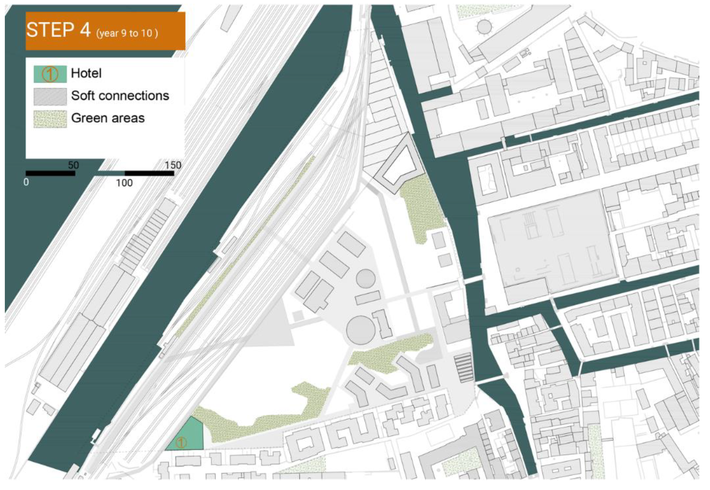
The last step (year 9 to year 10, see the image of step four, Figure 7) is a bet on the future. The idea of proposing a tower building for hotel use at the southwest corner of the plot is justified by the conviction that, in the last phase of the real estate transaction, the land value has increased to such an extent that it also justifies the higher construction costs associated with this type of building.
Finally, a communication strategy is developed based on the key elements: the innovative elements of the site, the possibility to easily reach the area both by road and water and the combination of commercial and public spaces that foster social integration.
5. Discussion
The methodology applied is based on a holistic strategy that combines remediation techniques, urban and architecture design that is guided by adaptive reuse strategies, economic feasibility and social empowerment. It can be effective if the steps’ timing is following the economic and social impact of the entire transformation, adapting to the responses of the different phases [31,32,33]. This is a long-term process following an adaptive reuse design approach, where the timing is crucial for the positive achievement of the transformation and the return of the investments.
Although the application of our methodology is the result of an academic study and not of a real transformation process, it is possible to develop some reflections. This methodology is aimed at supporting DMs in defining intervention strategies that are highly flexible and tend to be time consuming. Such aspects can be read as positive and negative at the same time.
The positive aspect of the flexibility in the transformation strategies is that it allows one not to bind territories with urban planning tools that risk being a limitation instead of an incentive; one should in fact favour quick reactions to possible market variations, social and economic changes, etc. Thus, the designing of the site follows different steps and the hypothesis of the construction of the buildings follows the timeline of the clean-up procedures, allowing the effective use of the soil both in terms of the building construction and the creation of public open spaces and parks. At the same time, an effective reconstruction and reuse of the historic buildings offers additional space and could host many of the new functions settled by the new masterplan proposal. Using the existing buildings as much as possible is of primary importance and, in the present case study, brought a reduction of half the needed amount for a new building’s construction. Nevertheless, the downside of the flexibility is that such a strategy requires a “continuous effort” to systemise the different specific competences, adapting to the ongoing changes with the awareness that the correct timing of the phasing of the interventions is crucial in this case.
A potentially “time consuming” strategy, constructed to control how the remediation activities develop in time and how they integrate with the transformation projects, has the advantage of allowing the project to function harmonically, which brings synergy effects among the different interventions. In addition, although it requires much more negotiation, this strategy is more likely to find investors for smaller interventions than just performing singlehanded interventions. The negative aspect is evident to the point of being tautological.
6. Conclusions
The present paper proposes an incremental economic and architecture strategy for evaluating a project to reactivate the abandoned industrial area of Ex-Italgas Santa Marta in Venice, Italy. In particular, the proposed application has the purpose of gaining an understanding of the overall suitability of the area under analysis to trigger transformation processes with low initial capital and an intense design activity.
This paper highlights the advantages of an incremental economic and architecture strategy for the remediation of polluted ex-industrial sites with specific reference to their ability to support a decision-making process through a systematic masterplan design according to the pollutants, their zone distribution and the remediation techniques, and is facilitated by the use of the pollutants’ maps.
The main advantage of this incremental approach is the fact that decision makers can develop short, medium and long term transformation strategies, keeping and reusing as much of the existing buildings and facilities as possible and increasing the public interest towards the area, attracting investors and stimulating a mechanism to rise the market value of the real estate property.
The results of the proposed application show that interesting findings in terms of warning levels can derive from the comparison of the spatial distribution of pollutants and the final suitability map of the area for different uses. The identification of warning levels can support spatial planning and economic choices, differentiated according to the level of the remediation difficulty.
Our study had some limitations that can be addressed through future research.
First, although we applied our new methodology to a real case with interactions with real DMs, the approach was not actually used in the decision-making process that led to the choice of which transformation to implement on the abandoned industrial area of Ex-Italgas Santa Marta investigated here. We acknowledge that better external validity, reproduction of organisational life and the inherent complexity and uncertainty would have been achieved within an effective decision-making process. Second, the methodology has so far only included techniques related to the profitability of the real estate operation, while cost–benefit analyses could be added to assess the externalities generated by the rehabilitation project of a former industrial area.
In this sense, there are still a number of opportunities for expanding research and for validating the results obtained herein. First, future research could combine this approach with an analysis highlighting the possible benefits and impacts on the community, such as the Social Return of Investment (SROI). In addition, it would be interesting to carry out a series of the applications of this incremental approach on different types of former industrial areas to see if it is possible to generalise some reflections on the sequence of transformations according to the pollutants present on the site.
In conclusion, we can state that an approach integrating architectural design, pollutant analysis and economic feasibility testing constitutes a very promising line of research in the field of the adaptive reuse of former industrial areas.
Author Contributions
Conceptualisation, R.I., I.M.L. and M.R.; Investigation, R.I., I.M.L. and M.R.; Methodology, R.I., I.M.L. and M.R.; Writing—original draft preparation, R.I. Section 1, Section 2.2, Section 3.1 and Section 3.2 and I.M.L. Section 2.1, Section 2.4, Section 4, Section 5 and Section 6; writing—review and editing, R.I., I.M.L. and M.R. All authors have read and agreed to the published version of the manuscript.
Funding
This research received no external funding.
Institutional Review Board Statement
Not applicable.
Informed Consent Statement
Not applicable.
Data Availability Statement
Not applicable.
Conflicts of Interest
The authors declare no conflict of interest.
References
- Jacobs, J. The Death and Life of Great American Cities; Random House: New York, NY, USA, 1961; p. 188. [Google Scholar]
- Wong, L. Adaptive Reuse. Extending the Lives of Buildings; Birkhäuser: Basel, Switzerland, 2016. [Google Scholar] [CrossRef]
- Robiglio, M. RE–USA: 20 American Stories of Adaptive Reuse: A Toolkit for Post-Industrial Cities; Jovis Verga GmbH: Berlin, Germany, 2017. [Google Scholar]
- Ingaramo, R. Rust Remix; LetteraVentidue Editore: Siracusa, Italy, 2017. [Google Scholar]
- Ingaramo, R.; Pascale, L. An Interpretative Matrix for an Adaptive Design Approach. Italian School Infrastructure: Safety and Social Restoration. Sustainability 2020, 12, 8354. [Google Scholar] [CrossRef]
- Canevaro, E.; Ingaramo, R.; Lami, I.M.; Morena, M.; Robiglio, M.; Saponaro, S.; Sezenna, E. Strategies for the Sustainable Reindustrialization of Brownfields. In Proceedings of the IOP Conference Series: Earth and Environmental Science, Milano, Italy, 4–5 September 2019; pp. 1–12. [Google Scholar]
- De Dag Van Toen. Available online: https://www.dagvantoen.nl/grote-gifvondst-onder-nieuwbouwwijk-lekkerkerk/?lang=en (accessed on 5 April 2022).
- Science for Environment Policy. No net land take by 2050? Future Brief 14. Produced for the European Commission DG Environment by the Science Communication Unit, UWE, Bristol, UK. 2016. Available online: http://ec.europa.eu/science-environment-policy (accessed on 5 April 2022).
- Burchell, R.W.; Listokin, D. The Adaptive Reuse Handbook: Procedures to Inventory, Control, Manage, and Reemploy Surplus Municipal Properties; Rutgers University Center for Urban Policy Research: New Brunswick, NJ, USA, 1981. [Google Scholar]
- Loures, L.; Panagopoulos, T. From derelict industrial areas towards multifunctional landscapes and urban renaissance. WSEAS Trans. Environ. Dev. 2007, 10, 3. [Google Scholar]
- Bullen, P.A. Adaptive reuse and sustainability of commercial buildings. Facilities 2007, 25, 20–31. [Google Scholar] [CrossRef]
- Douglas, J. Building Adaptation; Routledge: New York, NY, USA, 2006. [Google Scholar]
- Ball, R. Re-use potential and vacant industrial premises: Revisiting the regeneration issue. Stoke Trent. J. Prop. Res. 2002, 19, 93–110. [Google Scholar] [CrossRef]
- Fabian, L.; Giannotti, E.; Viganò, P. Recycling City, Lifecycles, Embodied Energy, Inclusion; Giavedoni: Pordenone, Italy, 2012. [Google Scholar]
- Bocchi, R.; Ippolito, F. Riciclare la città. Istituto per i beni artistici e culturali (IBC) XXI 2013, 2, 1–5. Available online: http://rivista.ibc.regione.emilia-romagna.it/xw-201302/xw-201302-a0014 (accessed on 15 December 2021).
- Bullen, P.A.; Love, P.E. Factors influencing the adaptive re-use of buildings. J. Eng. Des. Technol. 2011, 9, 32–46. [Google Scholar] [CrossRef]
- Australian Government, Department of the Environment and Heritage. Adaptive Reuse: Preserving Our Past, Building Our Future; Australian Government, Department of the Environment and Heritage: Canberra, Australia, 2004. [Google Scholar]
- Hwang, S.W.; Lee, S.J. Unused, underused, and misused: An examination of theories on urban void spaces. Urban Res Pract 2019, 13, 1–17. [Google Scholar] [CrossRef]
- Micelli, E.; Pellegrini, P. Paradoxes of the Italian historic centres between underutilization and planning policies for sustainability. Sustainability 2019, 11, 2614. [Google Scholar] [CrossRef] [Green Version]
- Moroni, S.; De Franco, A.; Bellè, B.M. Vacant buildings. Distinguishing heterogeneous cases: Public items versus private items; Empty properties versus abandoned properties. In Abandoned Buildings in Contemporary Cities: Smart Conditions for Actions; Lami, I.M., Ed.; Springer: Cham, Switzerland, 2020; pp. 9–18. [Google Scholar]
- Lami, I.M. Shapes, Rules and Value. In Abandoned Buildings in Contemporary Cities: Smart Conditions for Actions; Lami, I.M., Ed.; Springer: Cham, Switzerland, 2020; pp. 149–162. [Google Scholar]
- Visconti di Massino, U. (Politecnico di Torino, Turin, Italy), “Real Estate Industry”, lecture held at the course “Economic Project Evaluation” (Prof. Isabella M. Lami). 3 November 2020. [Google Scholar]
- Hoesli, M.; Macgregor, B. Property Investment: Principles and Practice of Portfolio Management; Taylor & Francis: London, UK, 2015. [Google Scholar]
- Bishop, P.; Williams, L. The Temporary City; Routledge: New York, USA, 2012. [Google Scholar]
- Németh, J.; Langhorst, J. Rethinking urban transformation: Temporary uses for vacant land. Cities 2014, 40, 143–150. [Google Scholar] [CrossRef]
- Mecca, B.; Lami, I.M. The appraisal challenge in cultural urban regeneration: An evaluation proposal. In Abandoned Buildings in Contemporary Cities: Smart Conditions for Actions; Lami, I.M., Ed.; Springer: Cham, Switzerland, 2020; pp. 49–70. [Google Scholar]
- Robiglio, M. The Adaptive Reuse Toolkit. How Cities Can Turn Their Industrial Legacy into Infrastructure for Innovation and Growth. Urban and Regional Policy Paper. 2016, 38. Available online: https://www.gmfus.org/sites/default/files/Robiglio_AdaptiveReuseToolkit_Sept16_complete.pdf (accessed on 5 April 2022).
- Dyson, K.; Matthews, J.; Love, P.E.D. Critical success factors of adapting heritage buildings: An exploratory study. Built Environ. Proj. Asset Manag. 2016, 6, 44–57. [Google Scholar] [CrossRef]
- Baum, M.; Christiaanse, K. City as Loft: Adaptive Reuse as a Resource for Sustainable Urban Development; Verlag: Zurich, Switzerland, 2012. [Google Scholar]
- Bertaud, A. The Formation of Urban Spatial Structures: Markets vs. Design; Working Paper 7; Marron Institute of Urban Management: New York, NY, USA, 2014. [Google Scholar]
- Orange, H. Reanimating Industrial Spaces: Conducting Memory Work in Post-industrial Societies; Routledge: New York, NY, USA, 2016. [Google Scholar]
- Cramer, J.; Breitling, S. Architecture in Existing Fabric; Birkhauser: Berlin, Germany, 2007. [Google Scholar]
- Williams, K.; Dair, C. A framework for assessing the sustainability of brownfield developments. J. Environ. Plan. Manag. 2007, 50, 23–40. [Google Scholar] [CrossRef]
Figure 1.
The property development process (source: revised from [22]).
Figure 1.
The property development process (source: revised from [22]).

Figure 2.
The Ex-Italgas area (in red) located in Santa Marta district on Venice Island. Credit: the Authors.
Figure 2.
The Ex-Italgas area (in red) located in Santa Marta district on Venice Island. Credit: the Authors.

Figure 3.
Picture Ex-Italgas area. Credit: the Authors.

Figure 4.
Step one (year 0 to 4), the launching phase. Credit: the Authors.

Figure 5.
Step two (year 1 to 5), the valorising phase. Credit: the Authors.

Figure 6.
Step three (year 5 to 8), the stabilising phase. Credit: the Authors.

Figure 7.
Step four (year 9 to 10), the betting phase. Credit: the Authors.

Publisher’s Note: MDPI stays neutral with regard to jurisdictional claims in published maps and institutional affiliations. |
© 2022 by the authors. Licensee MDPI, Basel, Switzerland. This article is an open access article distributed under the terms and conditions of the Creative Commons Attribution (CC BY) license (https://creativecommons.org/licenses/by/4.0/).
Share and Cite
MDPI and ACS Style
Ingaramo, R.; Lami, I.M.; Robiglio, M. How to Activate the Value in Existing Stocks through Adaptive Reuse: An Incremental Architecture Strategy. Sustainability 2022, 14, 5514. https://doi.org/10.3390/su14095514
AMA Style
Ingaramo R, Lami IM, Robiglio M. How to Activate the Value in Existing Stocks through Adaptive Reuse: An Incremental Architecture Strategy. Sustainability. 2022; 14(9):5514. https://doi.org/10.3390/su14095514
Chicago/Turabian StyleIngaramo, Roberta, Isabella M. Lami, and Matteo Robiglio. 2022. "How to Activate the Value in Existing Stocks through Adaptive Reuse: An Incremental Architecture Strategy" Sustainability 14, no. 9: 5514. https://doi.org/10.3390/su14095514
Note that from the first issue of 2016, this journal uses article numbers instead of page numbers. See further details here.